
In recent years, wildfires have become a growing global threat, causing destruction and devastation to both the environment and human life. Every year, thousands of wildfires break out around the world, posing a challenge for first responders and policymakers in their efforts to contain and mitigate their impact.
In response to this challenge, Muon Space has launched its groundbreaking FireSat project, a 50-satellite constellation designed to scan the planet every 20 minutes and detect wildfires using multi-band infrared imaging. This innovative project aims to support and aid first responders and policymakers in their efforts to combat and prevent wildfires, bridging a critical gap in satellite-based wildfire detection.
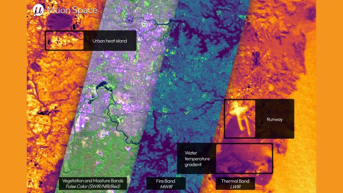
The FireSat constellation consists of 50 satellites orbiting the Earth, each equipped with advanced infrared imaging equipment. These satellites will work together to capture high-resolution thermal data, allowing for the detection of hotspots and active fires in real-time. With this real-time data, first responders and policymakers will have an accurate and up-to-date understanding of the current wildfire situation, allowing for more effective and efficient response and decision-making.
Thanks to the FireSat project, wildfires can be spotted and addressed quickly, reducing the risk of widespread damage and loss. The ability to scan the entire planet every 20 minutes also means that wildfires can be detected in their early stages, giving responders a better chance of containing them before they spread.
One of the main advantages of the FireSat constellation is its ability to provide high-resolution thermal data. Traditional satellite-based wildfire detection systems often struggle to accurately detect small fires or those hidden under thick smoke. However, FireSat’s multi-band infrared imaging technology can penetrate through smoke and clouds, providing a clear and detailed picture of the fire’s location and intensity.
In addition to aiding in firefighting efforts, the FireSat project also has potential benefits for policymakers. The data collected by the constellation can be used to create more accurate and reliable wildfire risk maps, aiding in land management and urban planning. This information can also be used to track changes in land use and vegetation, helping to identify areas at a higher risk of wildfires in the future.
Furthermore, the FireSat project also has the potential to improve our understanding of wildfires and their behavior. By continuously monitoring and collecting data on wildfires around the globe, researchers and scientists can gain valuable insights into the patterns and dynamics of these natural disasters. This information can then be used to develop more effective prevention and management strategies, reducing the risk and impact of future wildfires.
The first satellite of the FireSat constellation was successfully launched in March, marking a significant milestone in this groundbreaking project. Muon Space plans to continue launching additional satellites over the next few years, with the goal of completing the entire constellation by 2025. Once completed, the FireSat constellation will provide near-continuous coverage of the entire planet, further enhancing its capabilities and impact.
The FireSat project’s potential to support and aid first responders and policymakers in their efforts to combat and prevent wildfires cannot be understated. With its high-resolution thermal data and frequent scans of the planet, the constellation will provide invaluable and timely information for those on the front lines of fighting wildfires. It is an innovative and necessary step towards mitigating the threat of wildfires and protecting our planet.
In conclusion, the FireSat project by Muon Space is a game-changer in the fight against wildfires. Its multi-band infrared imaging technology, high-resolution data, and frequent scans of the planet will support first responders and policymakers in their efforts to contain and prevent wildfires. This revolutionary project not only bridges a critical gap in satellite-based wildfire detection but also has the potential to improve our understanding and management of these natural disasters. With the successful launch of its first satellite, the FireSat project is now on its way to make a significant impact and provide a safer future for all.
